One of the joys of the first UK Lockdown was learning new skills. I decided I’d learn how to create videos. You can read about it here.
Trying to create a show every week from scratch was hard work. So, for season two, we decided we’d film videos during the summer and then put them together into episodes in the Autumn. This has hopefully resulted in a more interesting show to watch as its not just shots of my garden for 10 weeks.
Here’s a preview of season 2.
There is no running/biking or swimming in the videos but it does fit into the general theme of this blog which is a love of Scotland and a passion for showing off all the great places you can visit.
John Muir was one of America’s most famous and influential ‘Outdoor Enthusiasts’ – although in a letter back to his native Scotland he did describe himself instead as a “poetico-trampo-geologist-botanist and ornithologist-naturalist etc. etc.” Which must be annoying to write when he was filling in the job title section of forms.
The John Muir Way is a 130 mile walking/biking route that stretches from his birthplace of Dunbar to where he left Scotland to head to America – Helensburgh.
I didn’t realize, until I looked at the route map, that I have actually done all of it but unintentionally whilst exploring various routes and paths along the Central Belt.
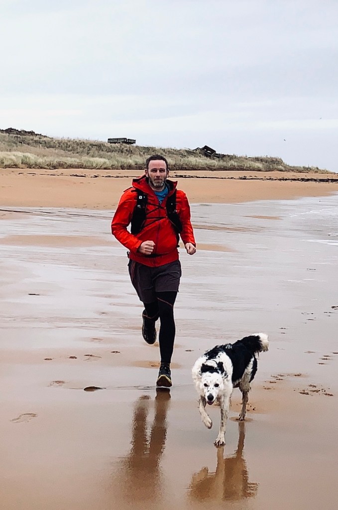
One of my favorite sections is Longniddry to North Berwick. I love the beaches in East Lothian and this section includes a run along one of the best: Yellowcraigs.
This section was easy to run. I parked my car in North Berwick. Got a train to Longniddry (10 minutes away) and then jogged back following the easy to follow route. There are lots of signs pointing out the route.
Its not a wild trail run, more like a mild trail run as it passes through some of the most affluent towns in Scotland. Its mostly flat and there are some sections near roads.
Parking
⭐⭐⭐⭐
Rating: 4 out of 5.
I had no problem parking in North Berwick but it can be busy on a nice day.
Facilities
⭐
Rating: 1 out of 5.
No facilities.
Nearest cafe
⭐⭐⭐⭐
Rating: 4 out of 5.
Plenty of options allong the route and in North Berwick.
Run Surface
80% off road, 20% pavement.
Dog Friendly
It depends on your dog. I ran with mine but she had to be on the lead a lot due to nearby traffic.
“Pinkston is home to Scotland’s only artificial whitewater course, a flat water basin with bathing quality water, meeting rooms and storage facilities for clubs and groups, Pinkston Watersports is an official Glasgow 2014 Legacy project and is operated by Glasgow Watersports Ltd, a registered Scottish charity run by a volunteer board of trustees.”
Threre is much debate about where the name Pinkston originates from. Supposedly the Scottish version of the name originated in the old barony of Pinkerton near Dunbar. The barony had the motto “Post nubila sol” which translates to “After clouds sunshine,” which is a fittingly apt motto for an outdoor pool because anyone who uses an outdoor pool needs a positive attitude – it might be cloudy today but the next time I swim it will be sunny!
I’ve used the facility for the last few years. It’s a great place to get an outdoor swim in a safe environment.
This year they have been running pay and swim session which has been hugely popular. During lockdown Pinkston was the only swimming pool that could open as it could operate in a COVID safe manner due to it being outdoors.
The only downside is that Pinkston can’t open the changing rooms to users. Everyone has to get changed outside. Which I think is a positive move as getting changed outdoors is a skill all outdoor swimmers have to learn.
I’ve been swimming regularly at 1700 on a Monday. Up unti this week (late Oct) the swim was in daylight. But this week the clocks went backwards. My 1700 swim became a night swim.
I didn’t realize just how dark the swim would be. I brought the wrong swim googles. I brought my shaded ones. I couldn’t see a thing. I was blinder than Stevie Wonder in a dark room with his eyes shut. I’m glad I did not record the swim on my GPS. It would have shown me swimming all over the place and, at one point, I’m sure I was swimming in a circle.
Lesson learned. I’ll bring a torch next time… and clear googles.
The area around Pinkston is getting regenerated. Local roads and access points are sometime closed so always check google maps first to find the best way there.
Water quality:
⭐⭐⭐⭐
Rating: 4 out of 5.
The water is murky. Don’t expect to see the bottom of the basin. The pool is not that deep. I can stand up at any point in it (I’m 6ft tall)
Swim Quality:
⭐⭐⭐
Rating: 3 out of 5.
Their is a 400m-ish loop when the basin is fully open. The site is open to the east and west which means it can be tricky swimming at sunrise/sunset as the Sun shines directly into your face.
Other People:
⭐⭐⭐
Rating: 3 out of 5.
Due to Covid regulations only a small number of people can swim at a time. It never feels busy and there is plenty of room to swim in.
Would I go back:
Yes – it is convenient to have somewhere in the city. It is good for beginners and it is a great starting point for people who want to move from the pool to outdoor swimming.
My Granny’s favorite mountain was Ben Lawers. She grew up in nearby Aberfeldy. During her youth she climbed Ben Lawers many times. Before she passed away she asked to be cremated so that her ashes could be spread upon the top.
So if you ever climb it, say hello to my granny. Knowing her, she will be haunting the trig point shouting at anyone nearby to stop chatting so she can concentrate on her crossword.
The Etape caledonia (https://www.etapecaledonia.co.uk/) uses some of the roads near Ben Lawers but I think this route is much more beautiful.
Video
Climb Review
Difficulty:
⭐⭐⭐⭐
Rating: 4 out of 5.
It can be brutal on a bad weather day but when the weather is nice its a steady climb but no big gradients.
Views:
⭐⭐⭐⭐⭐
Rating: 5 out of 5.
Views across Loch Tay on the way up. Views into Glen Lyon on the way down. Scotland at its best.
Traffic:
⭐⭐⭐⭐
Rating: 4 out of 5.
It’s normally a quiet road but there may be a few cars on the first part of the climb heading to the Ben Lawers car park to start climbing.
Parking
⭐⭐⭐⭐⭐
Rating: 5 out of 5.
I parked in Aberfeldy. There is plenty of parking.
Toilets
⭐⭐⭐
Rating: 3 out of 5.
There are public toilets in Aberfeldy but bring 20p to use them
Devilla Forest is just north east of the Kincardine Bridge. I’ve always been intrigued by the name. If it has ‘devil’ in the title it must be a pretty scary place – right?
Wrong! According to https://fife-placenames.glasgow.ac.uk/placename/?id=317 Devilla means “bad farm” because the land is bad for growing things. How boring. I’d have written he farm was bad because of devil worshiping. That would be a more exciting story.
The forest is slighly scary. It has a stone which a local legend says is marked by the grooves from a witches apron string. Do witches have aprons? I though aprons are just used by great British Bake Off contestants?!
Other than a dubious connections to baking witches there are four lochs, burns, meadowland and rich wildlife – including red squirrels. Lots of variety packed into a small area.
The route I choose was an eight mile loop from the car park. The routes is signposted but I’d advise taking a map or a GPS device with you. I took a couple of wrong turns and its easy to lose track of how to get back to the car park.
The paths were a mix of firetrack road and muddy trails. There isn’t much elevation on the route so its good for a flatter trail run.
It was pretty wet when I visited But I look forward to going back in better weather so I can see more of it. I might even spot a witch.
Wanlockhead is Scotland’s highest village. The area has Scotland’s highest hotel, Scotland’s highest pub, Scotland’s highest…you get the idea. The pub should sell its beer with the tagline “beer with altitude”
Above Wanlokhead there is a prominent golf-ball like structure on the summit of Lowther Hil. It is a radar station used by NATS (National Air Traffic Services).
The radar is known locally as “The Golf Ball” due to the ball shaped covering that protects the large rotating radar dish inside from wind and ice. It sits on a tee-like concrete structure.
I first attempted the climb in 2008. It was supposed to be the finish line of a bike sportive but the weather was so bad the road to the top was closed. Since then I’ve done it regulalry as a race against my brother. We call it the Tour De Golf Ball.
Check out the video to see what the route looks like
Here’s some images from the route
Video
Climb Review
Difficulty:
⭐⭐⭐⭐⭐
Rating: 5 out of 5.
It can be brutal on a bad weather day. I wouldn’t advise doing it if its windy. The climb is 2.6miles long and there are a number of steep sections.
Views:
⭐⭐⭐⭐⭐
Rating: 5 out of 5.
Great views across the Lowther hills On a clear day you can see for miles around.
Traffic:
⭐⭐⭐⭐⭐
Rating: 5 out of 5.
Its normally a quiet road and I hardly see a car but this time (Sep 2020) it was a a bit busier. I’m assuming more people are visiting now that lockdown has eased.
Parking
⭐⭐⭐⭐⭐
Rating: 5 out of 5.
There is a big area to park on the edge of Wanlokhead. Don’t park in the Lead mining museum. That’s for people visiting the museum.
Toilets
⭐⭐⭐
Rating: 3 out of 5.
There are toilets in the Museum but they were closed when I visited. Usually they are open and available
Cafe
⭐
Rating: 1 out of 5.
No Café stops on the route as Drumlanrig castle is currently closed to visitors. Normally you could stop there for a snack. They used to do excellent Scones.
The Lairig Ghru is one of the best-known mountain passes in Scotland. The only pass I’m familiar with is a bus pass. So I must admit I wasn’t aware of the Lairig Ghru until a couple of years ago. It featured on the BBC’s The Adventure Show.
The show covered the Lairig Ghru race. A mainly off road run which goes from the police station in Braemar to the police Station in Aviemore via the Lairig Ghru pass.
The race has been run annually for 40+ years but I can’t find any info on why the race starts and ends at a police station. Maybe race rules were officiated more strictly in those days.
The official route begins at the site of the old police station in Braemar. I got that slightly wrong. I started at the new police station. Thankfully, it only added on an extra 400m of running.
You can see what the route is like in the video below.
VIDEO
MAPS
Review
⭐⭐⭐⭐
Rating: 4 out of 5.
An interesting route. Varied running surfaces but it is very,very long so its not going to suit most people. The weather wasn’t great when i did it so I missed out on seeing some of the amazing scenery at its best.
Parking
⭐
Rating: 1 out of 5.
Logistically the run is a pain in the a$%e! I had to leave a car in Aviemore the day before the run, get a lift to Braemar (a 90 min journey). I then stayed in Braemar overnight before running the race and then driving back to Braemar to get my stuff.
Facilities
⭐⭐
Rating: 2 out of 5.
There is a bothy half way along the route. There are streams to get water but don’t expect to get any provisions until you are back in Aviemore.
Nearest cafe
⭐⭐⭐⭐
Rating: 4 out of 5.
There are plenty of options for food and drink in Aviemore. My dinner in Braemar was excellent (https://braemarlodge.co.uk/)
During Lockdown my employer made Friday’s a rest day. The idea being that having one day off a week during a pandemic is good for the mental well being and happiness of staff.
It was a great idea. I back any idea which means I work less but get paid the same! I’m not sure it was such a good idea for my productivity….
I used my Friday freedom to explore my local hills. I discovered miles of routes I’d never been on before. I wondered if it was possible to link up the best routes to make an interesting challenge. I mapped it out and the distance was 26 miles. Perfect for a marathon. Once I knew that I had to run it!
As the run is self supported I made it a figure of eight loop. This meant I could return to my car at the half way point and refuel and resupply.
The first loop of cort-ma-law is the easier loop. Its is very runnable and easy to work out a track. The second loop is harder at the beginning. The climb of Finglen is not on a clear track and encompasses a fair section of bog and heather.
The video will show you what to expect bu I don’t want to give a big description of the rout. The joy I had in running it was discovering new places. Hopefully if you try it you’ll get that thrill too.
VIDEO
MAPS
Review
⭐⭐⭐⭐⭐
Rating: 5 out of 5.
Its my own race so of course I’d rate it 5 stars!
Parking
⭐⭐⭐⭐
Rating: 4 out of 5.
There is a car park in Clachan of Campsie.
Facilities
⭐⭐⭐⭐
Rating: 4 out of 5.
There is a cafe next to the car park and there are pay toilets.
Loch Ard is the most common answer I hear when I ask the question “Where is your favorite place to swim?”
Which is due to:
a) Most people I ask live around Glasgow and can easily get to Loch Ard; and
b) it’s a great place to swim.
The loch is referred to in Wikipedia as “one of the smallest lochs in Scotland” which does not sound correct to me as its not even the smallest loch near Aberfoyle: Loch Chon and Loch Achray are smaller than Loch Ard.
In fact I can prove it’s not the smallest. This week I discovered a website that lists everything you ever want to know about a loch but are too afraid to ask.
It is basically depth maps of lochs and a link to a loch guide. The guide is a very dry read. It makes the brexit trade negotiation documents seem like a barrel of laughs.
What’s interesting is seeing where lochs are shallow and where they are deep. It answers the question: why did I get cold in that bit of the loch but not this other part?
Scotland has a few FKT’s, mostly on long distance walking routes or high level routes. For example, the John Muir Way is 215 km and it is recommended you takes 8-9 days to walk it. The FKT for the route is 21 hours 53 minutes. John Muir is famous for his quote: “The mountains are calling and I must go”. I feel that should be changed to: “The mountains are calling and I must go… at full speed whilst being tracked by GPS and two witnesses otherwise it won’t count as an FKT.”
The Fife Coastal Path is 187 km and the FKT is just over 14 hours. I started walking the Fife Coastal path in 2011. In the nine years since then I have only walked half of it. I’m on course for a WKT – worst known time!
Maybe I’d be quicker if I did not stop in St Andrews for a fudge Donut.
I’d much rather have a WKT than a FKT. A WKT says that I took my time and enjoyed a run. I savored every view, I walked or stopped when I felt like it. A WKT is a sign I enjoy running for what it really is – time outside. It is nothing more than that. So, forget records, speed and distance and just enjoy the outdoors.
Addendum – I will one day finish the Fife Coastal path but at my current rate of progress it looks like it will be in the year 2035.