Category Archives: Rugged Run

Rugged Run – Ben Cleuch (Iain)

Ten years ago, I met my wife on a walk up Ben Cleuch so when I recently suggested we head there for a walk I expected here to say “Oh, that’s where we met” instead she said “Where? I’ve never heard of it.”

Our initial meeting can’t have been very memorable!

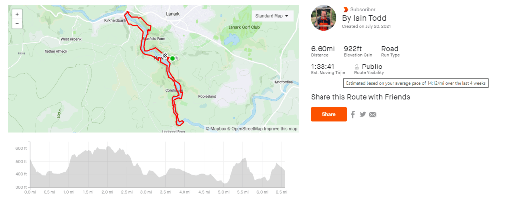
The walk starts in Tilicoutry. There is plenty of parking near to the start. When I last did the walk I went up via a path in Tilicoutry Glen but a sign at the start of the walk said that route was closed due to damage to the path.

There is a suggested diversion so we took that instead of the route through the glen. The route was easy to follow as it was well signposted.

There was allot of climbing. The walk start at an eelvation of 60m and keeps going up until you are at 700m. Only the last section on the summit is relatively flat. 

We could have gone back down the way we came but instead we decided to do a circular route. This would come down via the damaged path. I was hopeful it wasn’t too damaged but I was slightly concerned when we didn’t meet anyone coming up via that way.

Thankfully the damage to the path was just a missing section of wooden walkway. It was very easy to get past.

Ben Cleuch is a nice walk. Its not too challenging (other than the steepness.) There was nice views across central Scotland from the top.

Check out the video to get a feel for the route.

MAPS

https://www.strava.com/routes/2867789784493628438

Review

Rating: 3 out of 5.

Nice route but a bit dull. I think I’d enjoy it more in winter with a bit of snow on the ground.

Parking

Rating: 4 out of 5.

There was plenty of spaces to park near the start.

Facilities

Rating: 1 out of 5.

None

Nearest cafe

Rating: 4 out of 5.

There are cafe’s and shops in Tilicoutry

Run Surface

100% trail

Dog Friendly

Yes as long as they like hills.

Elevation

721m

Rugged Run – The Postman’s Path on the Isle of Harris (Iain)

The postman’s path connects the small town of Tarbert with the even smaller town of Rhenigidale on the south-east edge of the Isle of Harris.

Until 1989, the only way for the outside world to reach Rhenigidale was by boat, or by this path. Goods and post were taken in and out via this route. Which meant a very long walk for the postman. Thankfully Amazon did not exist back then or he’d never have been able to carry all the post over the hill.

The route is a 13 mile circular path starting in Rhenigidale. TwinbikeAndrew thought it was going to be 10km!

There is parking in Rhengidale and the path is very obvious. Just make sure when you get to the Scalpay side that you take the path on the West side of the Loch. The East side also has a path but it ends after about a mile.

MAPS

https://www.strava.com/routes/2874326492451568174

Review

Rating: 5 out of 5.

Spectacular Views on a nice day

Parking

Rating: 4 out of 5.

There is a car park at the start of the run.

Facilities

Rating: 1 out of 5.

None

Nearest cafe

Rating: 1 out of 5.

Nothing nearby but there are a couple of places in Tarbert.

Run Surface

100% trail

Dog Friendly

Yes as long as your dog likes hills!

Elevation

740M of elevation.

Rugged Run – Ben Cruachan (Iain)

I’ve never had a desire to climb all the Munro’s. I’d rather just climb the good one’s again rather than do one of the less interesting ones. Why spend a day going to climb the 282nd most interesting Munro when you could go and climb one of the top 100 or even the top 10 most interesting?

Climbing a hill just to tick it off a list seems a bit pointless.

Which is why, I’ve only every climbed about 20 Munro’s but I’ve done them all multiple times and they are all some of the most interesting (to me) one’s!

This was my fourth time up Ben Cruachan. The last time I was there was a few years ago, it was the hottest day of the year and of the ten people I was with who started the walk. Only 4 got to the top. The rest conked out in the heat on the way up.

This time the forecast was for it to be even hotter than that day but when we got to the hill it was very cloudy and overcast. Check out the video to see how we got on….

MAPS

https://www.strava.com/routes/2871762937338348116

Review

Rating: 5 out of 5.

One of my favorite munro’s but its a hard slog. Do it on a nice day so the views at the top are good.

Parking

Rating: 2 out of 5.

There is a small car park at the start but if its full you will have to park 1km away from the start.

Facilities

Rating: 1 out of 5.

There are no faciliteis at the start of the walk.

Nearest cafe

Rating: 3 out of 5.

There are a few cafe’s nearby but I didn’t stop at any of them.

Run Surface

70% trail, 30% firetrack road. The trail is a mix of rough paths and rocky routes.

Dog Friendly

yes

Elevation

1100 m

Rugged Run – The Falls of Clyde(Iain)

Can a good walk be spoiled by a terrible journey to it?

The Falls of Clyde should be a good walk. It ticks all the boxes of things I like. Its is very scenic, it has unique sights (the village) and there are options to make it a short or long route BUT I hated driving to it.

I hated it because the roads were awful, I got lost and I spent twice as much time in my car than my Sat nav claimed it would take.

By the time I started the walk I was in a foul mood so I did a short route out and back route rather than a full loop. Check out the maps below to see the options.

I enjoyed the walk. It was long enough for me. The route is very well signposted so I won’t bother putting directions here. Just follow the signs to the falls.

MAPS

Short Route:

https://www.strava.com/routes/2859444495775347268

Long Route:

https://www.strava.com/routes/2852569720978813142

Review

Rating: 2 out of 5.

Nice walk but it is not a nice drive to get to (from my house)

Parking

Rating: 5 out of 5.

There is a big car park.

Facilities

Rating: 4 out of 5.

There are toilets, cafes and plenty of shops nearby.

Nearest cafe

Rating: 4 out of 5.

There is a cafe in New Lanark visitors centra.

Run Surface

100% trail

Dog Friendly

yes

Elevation

300 m

Rugged Run – Mangersta Bothy (Iain)

Mangersta bothy was built into the side of the Mangersta cliffs, on the Isle of Lewis, almost 30 years ago by two locals, John and Lorna Norgrove.

John and Lorna are the parents of Linda Norgrove who was involved in a terrible accident in Afghanistan in 2010. She was killed by US soldiers. You can read the details about the case here https://en.wikipedia.org/wiki/Death_of_Linda_Norgrove

Her parents setup a foundaton in Linda’s memory. You can read more about how to stay in the bothy at https://lindanorgrovefoundation.org/mangersta-bothy/

The bothy is in a very remote part of the Isle of Lewis but the walk out to it is relatively simple. Park at the end of Mangestera village and follow the fence westward. The both is tucked into the cliffs near the end of the fence line.

I would not recommend the walk to anyone with young children or anyone who is uncomfortable with heights. Their are allot of steep cliff drops in this area.

I would be scared to spend a night in the bothy in case I needed the loo during the night. I might head out, trip and then never be seen again!

MAPS

https://www.strava.com/routes/2859442770365555268

Review

Rating: 5 out of 5.

The both is in a spectacular location

Parking

Rating: 3 out of 5.

There is space, at the start of the walk, to park a couple of cars.

Facilities

Rating: 1 out of 5.

None

Nearest cafe

Rating: 3 out of 5.

There is a cafe and shop within 15 minutes drive.

Run Surface

100% trail

Dog Friendly

I wouldn’t recommend it.

Elevation

0m

Rugged Run – Crathes Castle Garden (Iain)

Walled gardens are great for gardeners as they provide shelter from bad weather to allow the creation of a perfect growing environment.

They are not great places places to visit on the hottest day of the year.

The walls made it feel like I was trapped in an oven and that the chef had forgotten to take me out whn my time was up!

The video does not do justice to how hot it was!

MAPS

Review

Rating: 2 out of 5.

I didn’t walk far but it looked like a nice place for a run/walk.

Parking

Rating: 4 out of 5.

There is a car park next to the castle.

Facilities

Rating: 3 out of 5.

Toilets

Nearest cafe

Rating: 1 out of 5.

There is a cafe next to the castle.

Run Surface

100% trail

Dog Friendly

Yes

Elevation

0m

Rugged Run – Luskentyre Beach (Iain)

When I was young my next door neighbor stood in a general election as the Liberal Democrat candidate for the western isles.

Unfortunately the western isles wasn’t interested in the party of Paddy Pantsdown. My neighbor struggled to get any support. Eventually he became so frustrated at his lack of coverage at hustings and in the press that he started inventing wilder and wilder election pledges.

His wildest was a promise that if he was elected he’d build pyramids in the moors of the Isle Of Lewis. His reasoning was logical – building pyramids would create jobs and once they were built they’d increase tourism thus creating even more jobs.

Unfortunately his radical idea failed to win any votes! The island was not yet ready to build a Gaelic Tutankhamen tomb.

He probably thought his idea was original but Scotland already has a homemade pyramid. It is hidden away on a hillside on Balmoral estate on a path known only to instagrammers and people who google “how to find balmoral pyramid?”

When I die I’d be happy with just some flowers and some cards. I don’t like to make a fuss.

To access the cairn you can either pay money to enter the estate or you can walk a bit further and start at Easter Balmoral estate. From here there is free access to the estate. At least I hope it’s free. Maybe the queen sets the SAS on you if she spots you sneaking in. If you get shot don’t blame me.

MAPS

https://www.strava.com/routes/2855457181965568636

Review

Rating: 3 out of 5.

A nice forest walk but a bit samey after a while.

Parking

Rating: 4 out of 5.

There is a big car park next to the estate.

Facilities

Rating: 3 out of 5.

Toilets

Nearest cafe

Rating: 4 out of 5.

THere are a couple of cafes next to the car park.

Run Surface

90% trail, 10% concrete

Dog Friendly

Yes but I think there was a note asking they be kept on a lead.

Elevation

300m

Rugged Run – Lochnagar (Iain)

Lochnagar is the second highest mountain in Scotland….I thought.

It isn’t.

But whilst I was hiking it I was convinced it was. I’d miss read an article and it was only afterwards when my wife checked my “fact” that we discovered the truth.

Lochnagar is only number 7 on the list of highest Scottish hills. This explains why, when I reached the top, I thought to myself “that was surprisingly easy for the 2nd highest mountain!”

Lochnagar is not a technical hike. In good weather it’s a long slog on good paths. We did the route in the classic anti-clockwise direction. I think the views are better this way. Although it ends with a long walk along the loch.

It was one of the hottest days of the year when we did it but it was hard to notice the heat due to the wind. It was so windy that later in the day some poor soul was blown over and broke a leg!

MAPS

https://www.strava.com/routes/2855456124183016700

Review

Rating: 4 out of 5.

A nice plod with nice parts but there are some long boring sections with not much to see.

Parking

Rating: 3 out of 5.

There is a car park next to the start but it can fill up quickly especially at weekends. It was full by 0830 on the day we visited. The car park has a charge.

Facilities

Rating: 4 out of 5.

There are toilets and a stall selling cakes, cofee’s and ice creams.

Nearest cafe

Rating: 5 out of 5.

There is one at the car park.

Run Surface

100% trail

Dog Friendly

Yes but there is not much water stops until the second half of the route.

Elevation

937m

Rugged Run – Buachaille Etive Mòr (Iain)

Buachaille Etive Mòr is one of Scotland’s most photographed mountains as one of Scotland’s busiest tourist routes passes right by it. The A82 – the main road connecting Glasgow and the Highlands via Fort William.

I hate the A82. I know it’s supposed to be one of Scotland’s most scenic drives but it is horrifically slow to drive with limited places to overtake. Every tourist who slows down to check out the photographic face of Buachaille Etive Mòr causes a tailback that stretches all the way back to Glasgow.

I jest but I did once spend two hours on the A82, due to tailbacks caused by cars trying to go to Glencoe’s ski resort, butI only travelled 2 miles. I was heading to climb Buachaille Etive Mòr but I gave in and returned home. Unfortunately I felt unwell. I spent a miserable 3 hours driving home whilst stopping every 30 minutes to throw up.

I try to drive the A82 as little as possible. But due to a combination of amazing weather and a vacation day I decided to face the beast road and climb Buachaille Etive Mòr.

I was surprised at how few people were on the hill. Even in bad weather I’ve never been up without at least half a dozen other groups present. I think the hot weather had put people off.

I spoke to one man who was doing it too and he that he was on holiday in Glencoe and he thought he’d be out every day but due to the heat he was only managing to get out every second day. On his days off he was sitting a garden drinking beer.

That sounds like a good holiday!

MAPS

https://www.strava.com/routes/2855454549173274876

Review

Rating: 5 out of 5.

Amazing weather and views.

Parking

Rating: 3 out of 5.

There is a car park next to the start but it can fill up quickly especially at weekends.

Facilities

Rating: 1 out of 5.

None

Nearest cafe

Rating: 2 out of 5.

There are cafe’s in Tyndrum or Fort William

Run Surface

100% trail

Dog Friendly

Yes but its very steep in places.

Elevation

0m

Rugged Run – Luskentyre Beach (Iain)

What a difference a day makes. If you look at the image from this video you wouldn’t guess that just 24 hours earlier it was cold, wet and there was zero visibility!

The most annoying thing about that was that the weather forecast for the bad day was for glorious sunshine.

The only thing you can rely on about Scottish Weather is to expect the unexpected. Never leave the house without a precautionary jacket.

Luskentyre beach is the most famous beach in Outer Hebrides and it is commonly mentioned as one of the best in the world. Although I wouldn’t even rate it amongst the top 5 beaches in the Hebrides!

Its nice but there are more spectacular ones on the island. Check out Uig or Tolsta to see much better ones.

The video shows just how much difference a day makes. It was filmed over two days. I think you might be able to tell which day was which.

MAPS

Review

Rating: 4 out of 5.

A beautiful beach

Parking

Rating: 4 out of 5.

There is a car park next to the beach but it can fill up with camper vans in summer.

Facilities

Rating: 3 out of 5.

Toilets

Nearest cafe

Rating: 1 out of 5.

Nothing nearby but there is a small shop in Tarbert.

Run Surface

100% beach

Dog Friendly

Yes

Elevation

0m